Grass Over the Sleepers: Five Lost Railways That Make a Fine Day Out
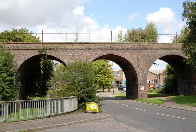
Photo: Andy F, CC BY-SA 2.0, via Wikimedia Commons
There is a particular kind of quiet on a railway that no longer runs. The cutting walls remain, the gradients stay gentle — trains demanded nothing steeper — and the viaducts still carry something, just not carriages. Britain closed a great many lines in the last century, and a surprising number were never built over. They became footpaths, bridleways and cycle tracks, often with a station building at one end that looks faintly surprised to still be standing.
The appeal is not pure nostalgia. These routes are practical: flat, direct, and usually pointed at a town with a pub. What follows are five lost lines worth a day out, with notes on reaching each by car or by the trains that do still run.
The Monsal Trail, Derbyshire
The old Midland line between Bakewell and Buxton is the showpiece of the genre, and for once the showpiece deserves it. Headstone Viaduct carries the path over the Wye in a curve of five arches; below, the river does its polite limestone thing. Four tunnels are lit (seasonally, so check before an evening start), and the old stations at Bakewell and Millers Dale still anchor the route.
It runs about eight and a half miles end to end, on a compacted surface that suits bikes, pushchairs and anyone who has sworn off hills. By rail, Buxton and Chesterfield are the useful stations, both with buses to Bakewell; by car, the station car park at Bakewell is the obvious start. The detour up to Monsal Head for the classic view is short and steep, and the pudding shop in Bakewell is not optional.
The Mawddach Trail, Gwynedd
If the Monsal is the showpiece, the Mawddach is the one people remember. The line from Dolgellau to Barmouth closed in the 1960s, but Barmouth Bridge still carries the Cambrian coast railway — and a wooden walkway alongside it, which means you can walk the estuary and arrive by train at the same time. The nine miles are almost entirely flat, with the Rhinogydd on one side and the broad sand of the estuary on the other.
By rail, Barmouth is the obvious start; by car, Dolgellau has parking at the old station site. Penmaenpool station is now the George III hotel, which is exactly the sort of conversion these routes specialise in: a platform, a bar, and a view that has not changed. Keep an eye on the tide — the estuary empties dramatically, and the birds know it.
The Camel Trail, Cornwall
The Camel Trail has a good claim to be the oldest of the lot. The Bodmin and Wadebridge Railway opened in 1834, one of the first in the country, and the line survived long enough to become a trail from Bodmin through Wadebridge to Padstow. The Padstow section is about five and a half miles, flat and estuary-side, and busy in summer — go early or out of season.
By rail, Bodmin Parkway is the nearest mainline station, with buses onward to Wadebridge; by car, Wadebridge has plenty of parking. The old station buildings at Wadebridge and Padstow survive in other uses, and the path itself still feels like an approach line, curving into town rather than marching across fields.
The Dava Way, Moray
This is the one for people who want the quiet to be genuine. The Dava Way follows the old Highland Railway between Forres and Grantown-on-Spey, twenty-four miles of heather, viaducts and long views, with a remote middle section that feels further from a road than it is. The Divie Viaduct is the postcard moment, but the whole route has the peculiar spaciousness of a line built for a landscape rather than a timetable.
By rail, Forres is on the Inverness to Aberdeen line, and the trailhead is a short walk from the station. By car, there is parking at both ends. This one suits walkers and mountain bikes rather than road bikes; the surface is rougher, and the miles are real. Grantown's old station buildings have found new uses, and the town makes a sensible overnight.
The Hornsea Rail Trail, East Yorkshire
The line from Hull to Hornsea closed in 1964, and the trail that replaced it is now part of the Trans Pennine Trail. It is not dramatic — this is farmland, drains and big skies — but it has the thing that matters: a genuine sense of arrival. The old terminus building at Hornsea survives, and the approach into town still has the shape of a railway, even if the only thing arriving is you.
By car, Hornsea is an easy run from Hull; by rail, Hull is the nearest station, with buses onward. The route is flat and mostly traffic-free, and the coast at Hornsea is a proper reward — a promenade, a café or two, and a beach that is usually emptier than the ones further north.
A few practical notes
Surfaces vary more than the word trail suggests. Monsal and the Camel are smooth; the Dava Way is not. Tunnel lighting is seasonal, so a late start in winter can leave you in the dark. Station buildings are often in private or commercial use — admire from the path, not the car park. And check the trains before you commit: these routes are linear, and a return journey is part of the plan.
What makes these days out peculiarly British is not the nostalgia, exactly. It is the way the infrastructure outlived the service. The timetable vanished; the embankment stayed. You can walk a line that was built for steam and arrive at a pub that used to be a waiting room, and nobody finds that especially odd. That is the charm of it.